Protecting Wetlands
Wetlands are essential natural infrastructure. Across the Lower Galveston Bay Watershed, coastal marshes, freshwater wetlands, forested wetlands, and other interconnected habitats absorb and slow floodwaters, filter pollution, reduce erosion, and provide habitat for fish and wildlife.
Yet many of the wetlands that protect our region are being cleared, drained, fragmented, or filled as development expands. Stronger storms, rising seas, and continued growth make protecting the wetlands we have left increasingly urgent—especially where their loss increases flood risk for communities already burdened by inadequate drainage, industrial pollution, and decades of underinvestment.
What is a wetland?
Wetlands are places where water covers or saturates the soil permanently or seasonally. Some wetlands are visibly wet throughout the year, while others may appear dry during certain seasons. Their water conditions shape the soil, plants, and wildlife found there.
The Lower Galveston Bay Watershed includes both coastal and freshwater wetlands, from tidal marshes near Galveston Bay to forested wetlands, freshwater marshes, and bottomland habitats farther inland. Together, these landscapes connect our bayous, rivers, floodplains, and bays.
Why wetlands matter
Reduced flood risk
Wetlands provide space for water to spread out, slow down, and collect during heavy rain and coastal storms. Although no wetland can prevent every flood, protecting connected wetland systems can reduce the speed and volume of water moving toward homes, roads, and other developed areas.
When wetlands are filled or paved, rainwater has fewer places to go. Development can also push water downstream or toward neighboring communities, compounding existing drainage and flooding problems.
Improved water quality
Wetlands capture sediment and can filter excess nutrients and other pollutants before they enter bayous, rivers, and bays. Their plants, soils, and microorganisms work together to support cleaner water throughout the watershed.
Sustained fish and wildlife
Coastal marshes and other wetlands provide nursery, feeding, nesting, and spawning habitat for fish, shrimp, oysters, birds, and other wildlife. The health of Galveston Bay’s fisheries and the region’s extraordinary birdlife depends on healthy, connected habitats extending from inland wetlands to the coast.
Strengthened climate resilience
Wetlands can buffer communities from storm surge and erosion while storing carbon in their plants and soils. Protecting them is an important part of adapting to stronger storms, rising seas, and other effects of climate change.
Our challenges
As our region grapples with how to address increasingly larger and more intense storms and rising sea levels, protecting our remaining wetland areas at the highest risk of loss due to development and other reasons, becomes ever more important.
The over development of wetlands is exactly what we advocate against, using the clean water act as a tool for change to help guide our legal strategy for wetland protection. The CWA is the principle law governing pollution control and water quality of the Nation’s waterways. Section 404 Permits are required by the U.S. Army Corps of Engineers (USACE) in relation to work that will add or remove discharge of material in “waters of the U.S.” and associated wetlands. BCWK USES section 404 of the Clean-Water Act to protect our wetlands in Houston by making sure people developing these areas have the correct permits and have done the proper analysis for addressing flood protection.
How we protect wetlands
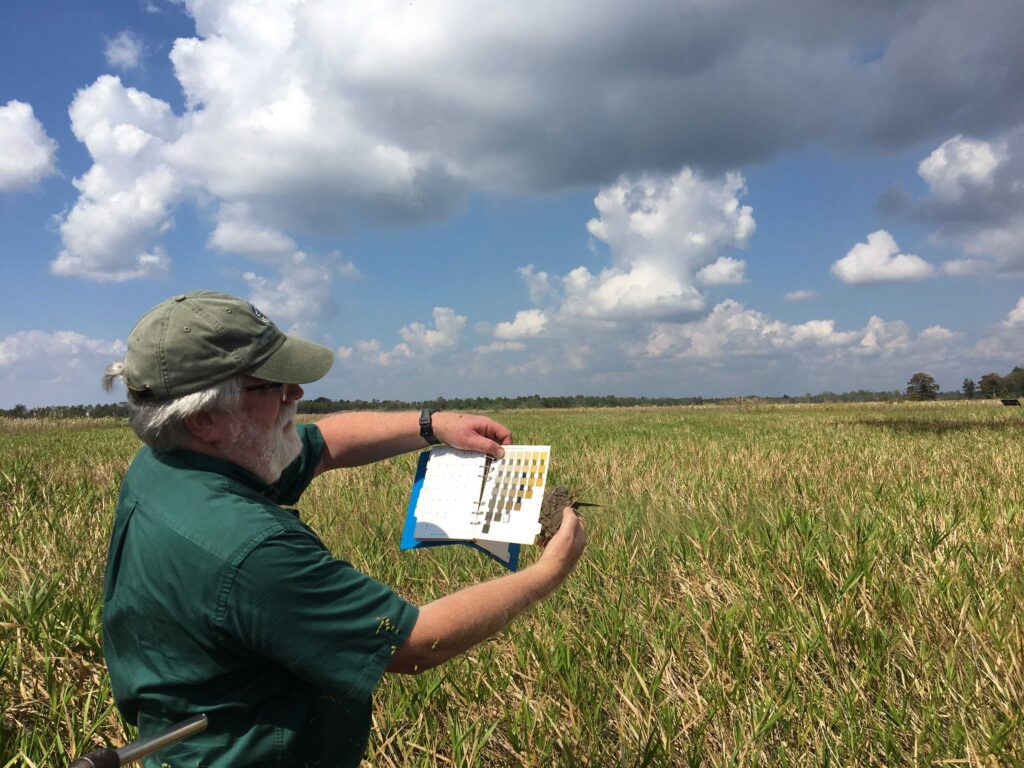
Bayou City Waterkeeper combines legal advocacy, policy change, research, mapping, and community knowledge to protect wetlands across the Lower Galveston Bay Watershed.
Our work includes:
- Monitoring proposed developments and federal permit applications
- Investigating whether projects have properly identified wetlands and evaluated their impacts
- Submitting public comments on projects that threaten wetlands and nearby communities
- Challenging unlawful or inadequate permitting decisions
- Providing residents and community partners with technical and legal support
- Advocating for stronger local and state protections that extend beyond the Clean Water Act
- Building public understanding of wetlands through mapping, education, and community-based programs
Section 404 of the Clean Water Act remains one of the principal federal tools available for protecting wetlands. Administered primarily by the U.S. Army Corps of Engineers, it regulates the discharge of dredged or fill material into federally protected waters, including certain wetlands. Depending on the project and the wetlands involved, developers may be required to avoid or minimize harm, seek a permit, and compensate for unavoidable losses.
Section 404 does not protect every wetland, however, and a permit does not necessarily prevent destruction. That is why BCWK also advocates for local and state policies that protect wetlands as connected natural systems—not simply as isolated acreage considered one development at a time.
Wetlands capture sediment and can filter excess nutrients and other pollutants before they enter bayous, rivers, and bays. Their plants, soils, and microorganisms work together to support cleaner water throughout the watershed.
Five critical wetland areas
Bayou City Waterkeeper has identified five areas containing some of the Lower Galveston Bay Watershed’s largest remaining concentrations of undeveloped wetlands and connected habitat. Protecting these landscapes can support a more comprehensive approach to flood resilience, water quality, climate adaptation, and habitat conservation.
Our Critical Wetlands work helps communities, advocates, and decision-makers see where wetlands remain, understand the threats they face, and make the case for protecting large, connected landscapes before they are fragmented by development.
This would be a natural place to either list the five areas or place a button leading to the dedicated Critical Wetlands page or Story Map.
Wetlands capture sediment and can filter excess nutrients and other pollutants before they enter bayous, rivers, and bays. Their plants, soils, and microorganisms work together to support cleaner water throughout the watershed.
Community resources
Wetlands mapping tool
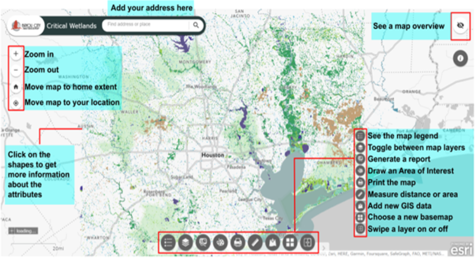
The wetland mapper has layers dedicated to wetlands mapped by the National Wetlands Inventory (NWI), the boundaries of the five most critical wetland areas, ecological land cover, flood hazard areas delineated by FEMA, county lines, the Lower Galveston Bay Watershed boundary, and the subwatershed boundaries. Users can toggle between these layers or view them simultaneously.
5 critical wetlands story map
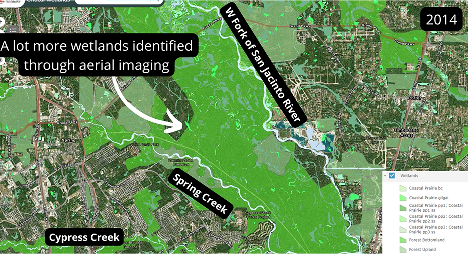
This story map illustrates the diverse ecosystems and wetlands in our region that are in need of protection. It lays the foundation for why conserving wetlands is critical especially in a post-Harvey environment, as they serve as one of nature’s best line of defense against flooding. Utilizing ecologic layers based on aerial imagery to identify large tracts of land in the Lower Galveston Bay watershed, we aim to identify and protect our critical habitats and our Texas coastal prairie wetland areas.